
May 25th, 2025. We arrived in Vasiliki on a Sunday evening. PredictWind — the gold standard, the tool professional sailors pay up to €249/year for — showed about 25 knots from the west. Sheltered bay, mountains on three sides, a dozen boats already on the quay. We picked up a spot on the town wall, stern-to, had dinner ashore, and turned in.
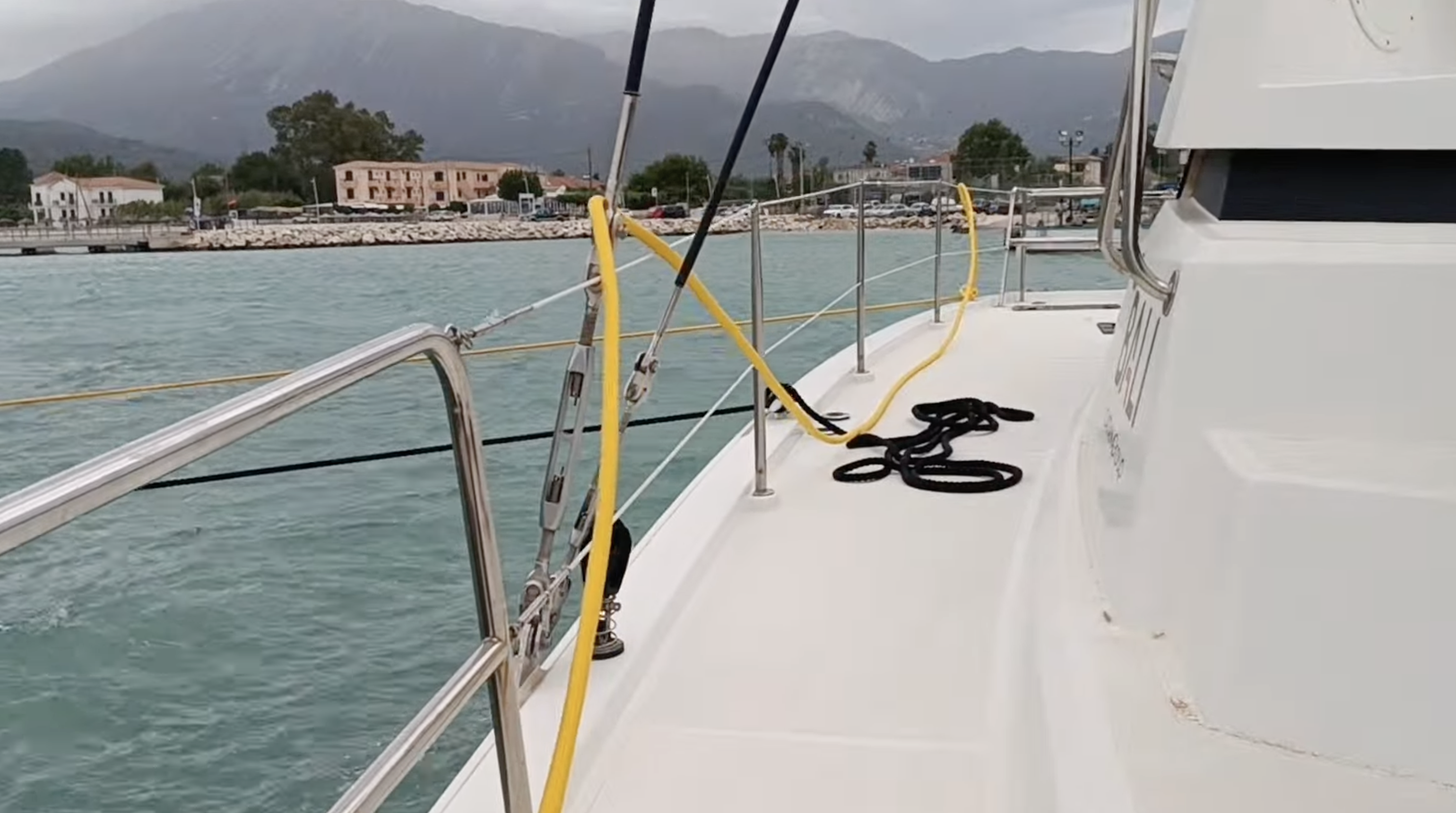
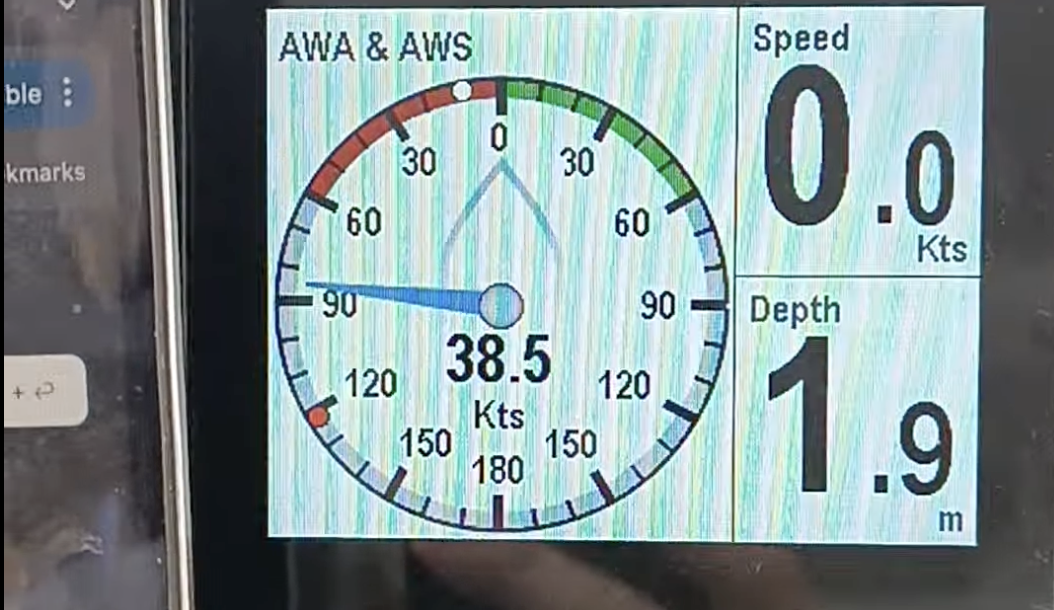
By 8 PM the boat was lurching sideways. Lines snapped taut. The fenders were grinding. Sustained 35 knots screaming straight down the mountain and across the bay — gusts nearing 40 — hitting us beam-on against the quay. It went on for hours, until around midnight. The boat next to us lost a cleat.
Every local at the taverna knew this would happen. "Vasiliki thermals," they shrugged. The afternoon westerly clears the mountain ridge and plummets into the bay — it's what makes the place a windsurfing mecca. The wind accelerates as it descends, compresses through the bay, and arrives at the quay far stronger than anything measured in open water. This is a katabatic wind. It happens most summer evenings in Vasiliki.
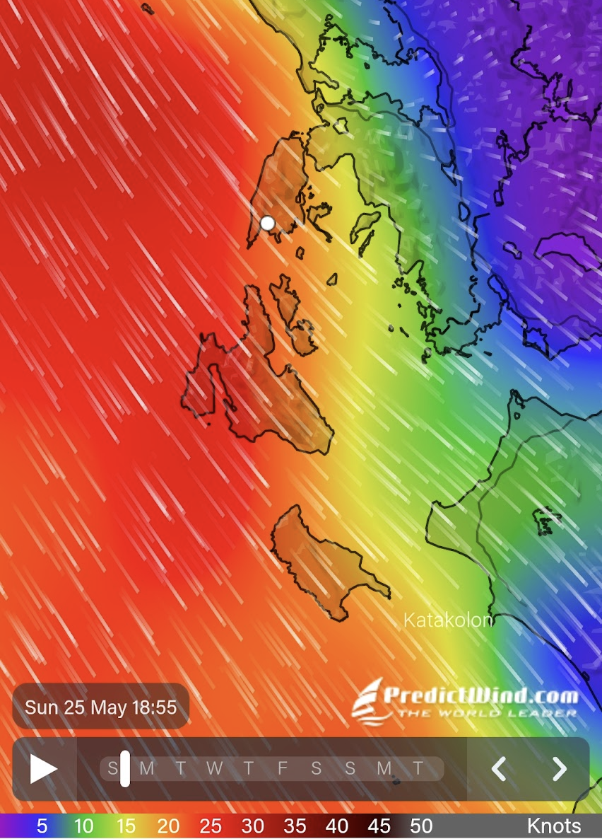
PredictWind showed 25. We measured 35 sustained, gusts near 40. That's 30% more than the best paid forecast predicted. The forecast wasn't wrong — it just had nothing to say about what happens when wind meets the specific shape of a specific bay.
Why weather apps go blind near coastlines
This isn't a bug in Windy. It's a physics problem. Every weather app you've ever used is drawing the same thing: a numerical weather model that divides the atmosphere into a grid and computes the wind at each grid point. The bigger the grid squares, the less detail you see.
22 km
GFS (free)
9 km
ECMWF
7 km
Windy (best)
1 km
PredictWind (paid)
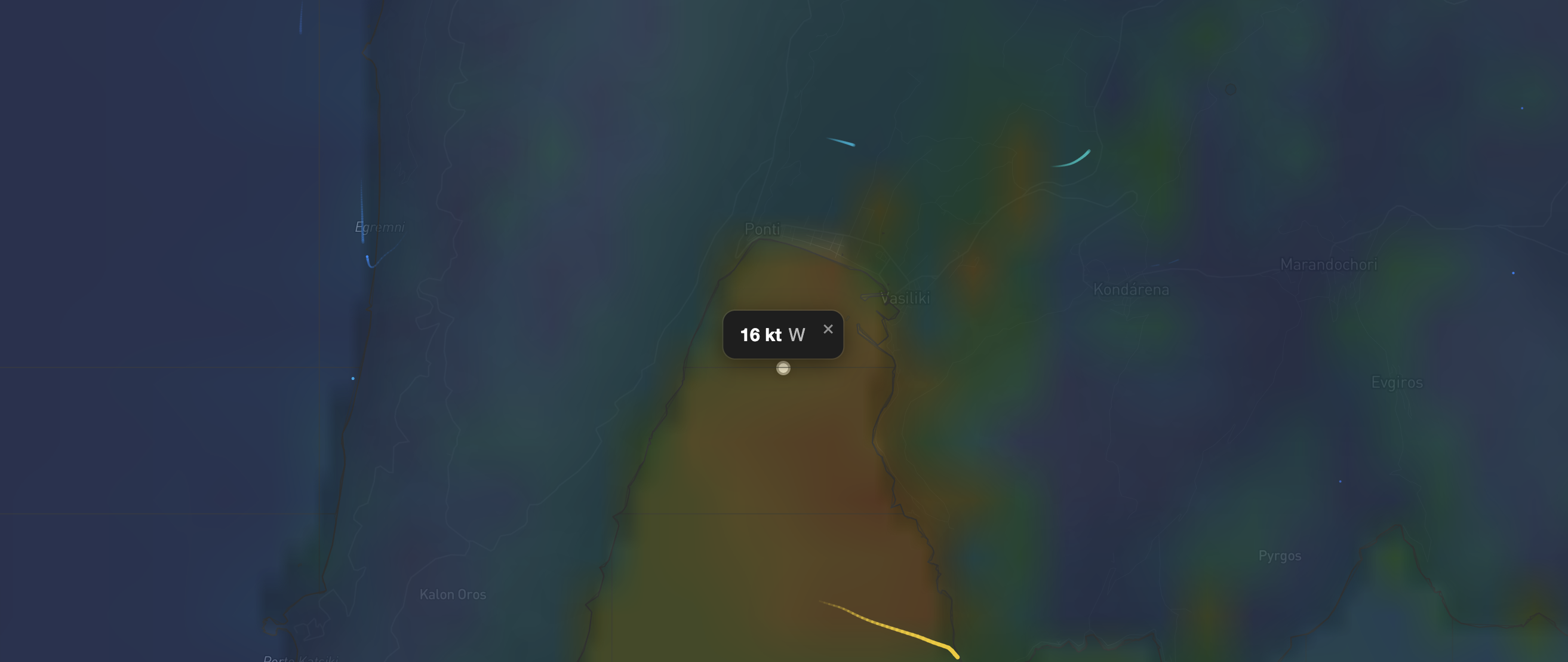
At the resolution most apps use (7-22 km), the entire bay of Vasiliki fits inside a single grid cell. The model doesn't know there's a mountain ridge behind the bay. It doesn't know the bay faces west. It gives you one wind number for the whole area — open water, the bay, and the mountain slopes, all treated the same.
This matters because everything interesting about coastal wind happens inside those grid squares. The speed-up between two islands. The calm patch behind a headland. The blast coming off a mountain slope at night. All invisible at 7 km resolution.
Five things that happen to wind near land (that you already know)
If you've sailed for a week in the Greek islands, you already know all of these from experience. You just couldn't see them on a forecast.
1. The funnel between islands
You know how it gets windier between islands? Same principle as putting your thumb over a garden hose — same amount of air forced through a smaller gap. The strait between Lefkas and the mainland is about 900 metres wide. A 20-knot westerly becomes 36 knots in that gap. The Meganisi channel does the same thing. So does the passage between Skorpios and Meganisi.
Your weather app shows 20 knots across the entire area. It physically cannot see the funnel because the strait is narrower than one grid cell.
2. The calm patch behind the island
Sail downwind of any tall island and you know the drill: the sails go slack, the boat slows to a crawl, and for a mile or two you're motoring through a wind hole. That's the mountain blocking the airflow — like standing behind a wall on a windy day. The higher the mountain, the longer the shadow.
This is also why some anchorages are paradise in a northerly but a nightmare when the wind swings south. The shelter is directional, and it depends on the shape of the terrain behind you.
3. The blast off the mountain
This is what hit us in Vasiliki. When wind is strong enough to clear a ridge, it doesn't gently descend the other side — it accelerates downhill like water pouring over a dam. The same thing happens on the lee side of any high island when the wind is blowing hard enough. Your forecast says 15 knots because that's what's happening at grid level. On the lee shore, you're getting 25.
4. The headland speed-up
Wind approaching a headland doesn't just stop — it splits and goes around, like water flowing around a rock. The sides speed up. If you've ever rounded a cape and been surprised by a sudden increase, that's the air being squeezed around the obstacle. The effect is strongest right at the tip and fades a mile or so downwind.
5. The approach calm
Sail toward a high coastline and you'll notice the wind dropping before you arrive. Your sails start luffing a kilometre out. That's the air piling up against the terrain and decelerating before it hits. Small effect — maybe 20% less than open water — but it explains the frustrating calm zone between your anchorage and the wind you can see ruffling the water further out.
What we built
We take the same freely available weather data that Windy uses and run it through a terrain model at 150-metre resolution — about 60 times finer than the standard forecast. The terrain comes from satellite elevation data accurate to 90 metres. The whole computation runs in your browser in under 200 milliseconds.
The idea is simple: the weather model tells us the wind at a coarse level. The terrain doesn't change. So we pre-compute all the mountains, straits, ridges, and coastlines at high resolution, and then adjust the forecast to account for what the terrain does to the wind as it passes through.
The result: instead of one wind reading per 7 km, you get one per 150 metres — with the funnels, shadows, and mountain effects baked in.
How we compare (honestly)
Let's be straight about what this is and what it isn't.
Windy is the best free weather visualisation tool on the internet. Global coverage, radar overlays, 50+ years of development. But it's built to show you the raw model output — it doesn't adjust for terrain. In open ocean, that's fine. Between Greek islands, it's blind.
PredictWind is the gold standard for serious offshore routing. They actually run their own 1 km weather model — real physics, not just terrain adjustment. If you sail offshore year-round, their €249/year Standard plan is worth every cent. But for a two-week charter holiday? That's €249 for 14 days of use. Their Basic tier (€29/year) gives you the 1 km maps without routing. And even at 1 km, the Vasiliki bay — only 2 km across — fell through the grid. They showed 25. We measured 35.
| Option | Price | Notes |
|---|---|---|
| Windy Premium | €19 | /year — better time resolution, but same 7 km spatial grid in Greece |
| PredictWind Basic | €29 | /year — 1 km maps, no routing |
| PredictWind Standard | €249 | /year — full routing + 1 km model + tidal currents |
| Charter.Boats | €0 | — 150 m terrain-adjusted wind, built into the platform |
We're not trying to replace either of them. Windy is great for the big picture — fronts, pressure systems, multi-day trends. PredictWind is essential if you're crossing the Atlantic. What neither of them does well is answer the question a charter sailor actually asks every evening: "Will this anchorage be okay tonight?"
That's a terrain question, not a synoptic question. And terrain doesn't change. Once you have a good enough elevation model and the physics to apply it, every future forecast gets coastal intelligence for free.
Pros
- 150 m resolution — sees straits, headlands, and mountain effects
- Free. No subscription. Comes with the charter platform
- Runs in your browser in under 200 ms — no waiting
- Click anywhere on the map to read the local wind
- Built on 25 m coastline data (our own water grid tiles)
- 72-hour forecast with hour-by-hour terrain adjustment
Cons
- We don't run our own weather model — we adjust the public forecast
- Currently covers the Ionian only (expanding region by region)
- No wave data yet
- No station observations or radar overlay
- PredictWind's 1 km model has better physics in complex weather
- Windy has 50 years of development and global coverage
Built for the casual sailor
If you're reading this, you're probably not a professional sailor. You charter a boat for a week or two in the summer. You check the forecast every morning. You've probably had at least one night where the forecast said one thing and the bay did something completely different.
You don't need a €30/month weather routing subscription. You don't need ensemble model comparisons or 10-day GRIB file downloads. You need to know three things:
- Will this anchorage be sheltered tonight?
- Is the strait I'm about to sail through going to be significantly windier than the open water?
- Should I leave early to avoid the afternoon thermal?
These are all terrain questions. Our wind map answers them. It's free, it runs in your browser, and it's built into the same platform you're already using to find your charter boat.
Where this is going
The wind map is step one. The same terrain model that adjusts the wind also knows which anchorages are sheltered, which passages are exposed, and which routes are comfortable at what wind speeds. Here's what we're building next:
Anchorage shelter alerts
Every anchorage rated by wind direction and speed. "Tonight shifts NW 20 kt — your bay is exposed. Here are 3 alternatives within 8 nm." Same terrain model, different question.
Weather-aware trip planning
Our trip planner already knows sea routes (real distances, not straight lines). Adding wind data means it can tell you which day to sail which leg — and when to stay put.
Arrival timing
"This anchorage fills by 2 PM in July." Local knowledge that experienced sailors carry in their heads, automated for everyone else.
More regions
We're expanding with our water grid tile system — 25 m resolution coastline tiles that enable both sea routing and wind downscaling. Croatia, Cyclades, and Sardinia are next.
The idea is that a charter sailor shouldn't need a shelf of expensive apps to stay safe and comfortable. One platform that knows the boats, the routes, the anchorages, and the wind — and puts it all together.
Try it yourself
The wind map is live. Set any wind speed and direction, or switch to forecast mode for the next 72 hours. Click anywhere to read the local wind. Toggle the grid overlay to see the coarse forecast points — and notice how much changes between them.
Open the Wind Map
Interactive 150 m wind forecast with terrain adjustment — Lefkas & Ionian Islands
Launch Wind Map